|
|

|
Processed through Paypal No account required. |
Buy our over-priced crap to help pay the bills.


|
|
|
Processed through Paypal No account required. |
| File - Download QGIS v3.22.2 | ||||||||
| Description | ||||||||
|
A plea... Deanna and I have been running this site since 2008 and lately we're seeing a big increase in users (and cost) but a decline in percentage of users who donate. Our ad-free and junkware-free download site only works if everyone chips in to offset the revenue that ads on other sites bring in. Please donate at the bottom of the page. Every little bit helps. Thank you so much. Sincerely, your Older Geeks: Randy and Deanna Always scroll to the bottom of the page for the main download link. We don't believe in fake/misleading download buttons and tricks. The link is always in the same place. QGIS v3.22.2 The Leading Open Source Desktop GIS QGIS is a user friendly Open Source Geographic Information System (GIS) licensed under the GNU General Public License. QGIS is an official project of the Open Source Geospatial Foundation (OSGeo). It runs on Linux, Unix, Mac OSX, Windows and Android and supports numerous vector, raster, and database formats and functionalities. Features QGIS offers many common GIS functions provided by core features and plugins. A short summary of six general categories of features and plugins is presented below, followed by first insights into the integrated Python console. View data You can view combinations of vector and raster data (in 2D or 3D) in different formats and projections without conversion to an internal or common format. Supported formats include: Spatially-enabled tables and views using PostGIS, SpatiaLite and MS SQL Spatial, Oracle Spatial, vector formats supported by the installed OGR library, including GeoPackage, ESRI Shapefile, MapInfo, SDTS, GML and many more. See section Working with Vector Data. Raster and imagery formats supported by the installed GDAL (Geospatial Data Abstraction Library) library, such as GeoTIFF, ERDAS IMG, ArcInfo ASCII GRID, JPEG, PNG and many more. See section Working with Raster Data. GRASS raster and vector data from GRASS databases (location/mapset). See section GRASS GIS Integration. Online spatial data served as OGC Web Services, including WMS, WMTS, WCS, WFS, and WFS-T. See section Working with OGC Data. Explore data and compose maps You can compose maps and interactively explore spatial data with a friendly GUI. The many helpful tools available in the GUI include: QGIS browser On-the-fly reprojection DB Manager Print layout Overview panel Spatial bookmarks Annotation tools Identify/select features Edit/view/search attributes Data-defined feature labeling Data-defined vector and raster symbology tools Atlas map composition with graticule layers North arrow, scale bar and copyright label for maps Support for saving and restoring projects Create, edit, manage and export data You can create, edit, manage and export vector and raster layers in several formats. QGIS offers the following: Digitizing tools for OGR-supported formats and GRASS vector layers Ability to create and edit multiple file formats and GRASS vector layers Georeferencer plugin to geocode images GPS tools to import and export GPX format, and convert other GPS formats to GPX or down/upload directly to a GPS unit (on Linux, usb: has been added to list of GPS devices) Support for visualizing and editing OpenStreetMap data Ability to create spatial database tables from files with the DB Manager plugin Improved handling of spatial database tables Tools for managing vector attribute tables Option to save screenshots as georeferenced images DXF-Export tool with enhanced capabilities to export styles and plugins to perform CAD-like functions Analyze data You can perform spatial data analysis on spatial databases and other OGR-supported formats. QGIS currently offers vector analysis, sampling, geoprocessing, geometry and database management tools. You can also use the integrated GRASS tools, which include the complete GRASS functionality of more than 400 modules. (See section GRASS GIS Integration.) Or, you can work with the Processing Plugin, which provides a powerful geospatial analysis framework to call native and third-party algorithms from QGIS, such as GDAL, SAGA, GRASS and more. Publish maps on the Internet QGIS can be used as a WMS, WMTS, WMS-C or WFS and WFS-T client, and as a WMS, WCS or WFS server. Additionally, you can publish your data on the Internet using a webserver with UMN MapServer or GeoServer installed. Extend QGIS functionality through plugins QGIS can be adapted to your special needs with the extensible plugin architecture and libraries that can be used to create plugins. You can even create new applications with C++ or Python! Core Plugins Core plugins include: Coordinate Capture (capture mouse coordinates in different CRSs) DB Manager (exchange, edit and view layers and tables from/to databases; execute SQL queries) eVIS (visualize events) Geometry Checker (check geometries for errors) Georeferencer GDAL (add projection information to rasters using GDAL) GPS Tools (load and import GPS data) GRASS 7 (integrate GRASS GIS) MetaSearch Catalogue Client (interacting with metadata catalog services supporting the OGC Catalog Service for the Web (CSW) standard) Offline Editing (allow offline editing and synchronizing with databases) Processing (the spatial data processing framework for QGIS) Topology Checker (find topological errors in vector layers) External Python Plugins QGIS offers a growing number of external Python plugins that are provided by the community. These plugins reside in the official Plugins Repository and can be easily installed using the Python Plugin Installer. Python Console For scripting, it is possible to take advantage of an integrated Python console, which can be opened with: Plugins ‣ Python Console. The console opens as a non-modal utility window. For interaction with the QGIS environment, there is the qgis.utils.iface variable, which is an instance of QgisInterface. This interface provides access to the map canvas, menus, toolbars and other parts of the QGIS application. You can create a script, then drag and drop it into the QGIS window and it will be executed automatically. Known Issues Number of open files limitation If you are opening a large QGIS project and you are sure that all layers are valid, but some layers are flagged as bad, you are probably faced with this issue. Linux (and other OSs, likewise) has a limit of opened files by process. Resource limits are per-process and inherited. The ulimit command, which is a shell built-in, changes the limits only for the current shell process; the new limit will be inherited by any child processes. You can see all current ulimit info by typing: $ ulimit -aS You can see the current allowed number of opened files per process with the following command on a console: $ ulimit -Sn To change the limits for an existing session, you may be able to use something like: $ ulimit -Sn #number_of_allowed_open_files $ ulimit -Sn $ qgis 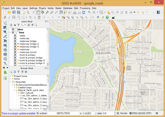  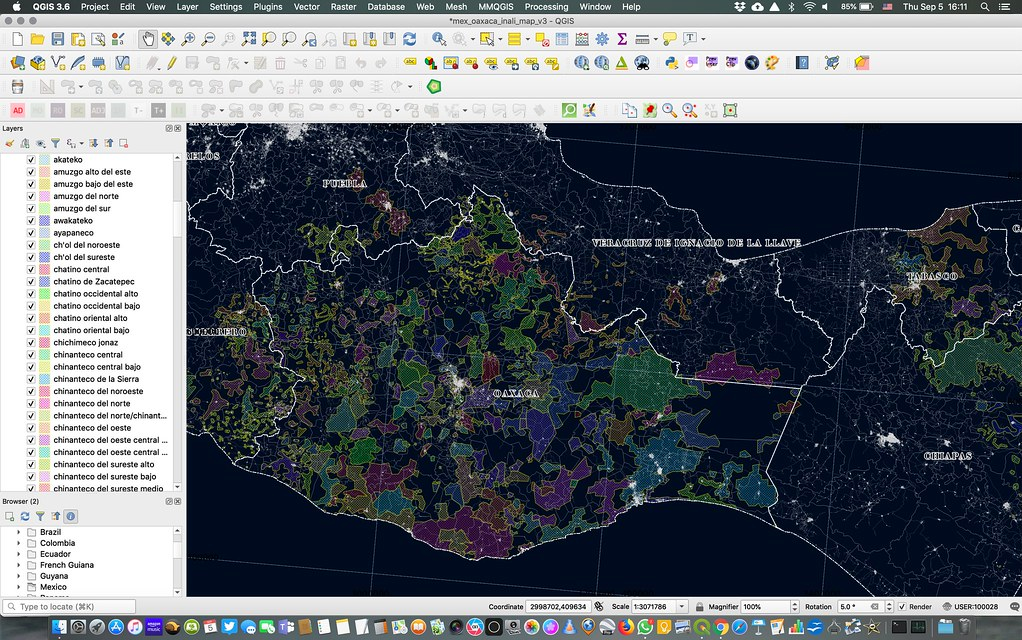      This download is for the Windows version. If you need the MacOS version, download here. If you need the Linux version, download here. Click here to visit the author's website. Continue below for the main download link. |
||||||||
| Downloads | Views | Developer | Last Update | Version | Size | Type | Rank | |
| 4,125 | 8,183 | qgis.org | Dec 23, 2021 - 12:56 | 3.22.2 'Białowieża' | 1014.96MB | MSI |  , out of 70 Votes. , out of 70 Votes. |
|
| File Tags | ||||||||
| v3.22.2 QGIS | ||||||||
Click to Rate File Share it on Twitter → Tweet
|